


Learning About The Glacial Geology Near Netcong, NJ
On the road…again!
Afghanistan to Zambia
Chronicles of a Footloose Forester
By Dick Pellek
Learning The Local Geology Around Netcong, New Jersey
OK, maybe he always was a slow learner. For sure he would never deny that he was slow to put things together. So it took 50 years to come to the wrong conclusion that what he saw out the back window of his house on Church Street may be a rock drumlin. Drumlins are geologic features that are associated with deposition of rocks and gravels under and along the sides of moving glaciers. The Wisconsin Glacier moved only a few miles south of Netcong before it began to recede. The farthest southward movement is marked by another feature known as a moraine, and the terminal moraine of the Wisconsin Glacier is famously noted in geology text books, including a remembered photograph of a road cut in the vicinity of Buttzville, New Jersey. When he took a geology course at Rutgers in the late 1950s, the professor took the class to Buttzville so we could see the terminal moraine for ourselves. Needless to say, the fascination with glaciers has remained for a lifetime. But why only now is he discovering the apparent truth about a drumlin in his back yard?
The answer has two parts: Part I has to do with a documentary about the recession of a large glacier in Greenland, complemented with graphics about the action of ice scouring and depositions. Part II is the refresher course on moraines and other glacial features in the counties north of Pittsburgh, close to where he presently lives. The current lessons include site visits to a western sector of that same Wisconsin Glacier. The Commonwealth of Pennsylvania established Moraine State Park there. But there are other glacial features in the area, and Footloose Forester acknowledges an excitement in searching them out, both on the ground and in viewing them on satellite photographs.
One of the features he had only seen in textbooks is called as esker, a serpentine deposition of sand and gravels that was once part of an internal stream under the glacier. That particular one is known as the Miller Esker or the Jacksville Esker and can be seen on a Google Earth satellite photo at 41º 00′ 29.43″ N and 80º 05′ 12.57″ W. There are also kames and kettle lakes in the matrix of ground moraines in the vicinity, thus one can always tread the landscape that contains them, in order to help visualize the dynamics of the glacial period.
Getting back to the Netcong area, he belatedly applied an analysis of terrain features to confirm for himself that the kames he knew as a boy do still exhibit topographic contour lines that suggest where they are. The “sandpit” behind Union Cemetery in Stanhope is part of a kame. And he will wager that one can find another drumlin just off Route 206 north of Andover, New Jersey; right next to a very small kame. The property has been altered through development, so the features are not as obvious as they once were. Note: More than a year later, a genuine geologist sent him an e-mail with the message that there is, indeed, a drumlin at Andover, NJ. He has since visited the site to witness its present-day land use as a pasture.
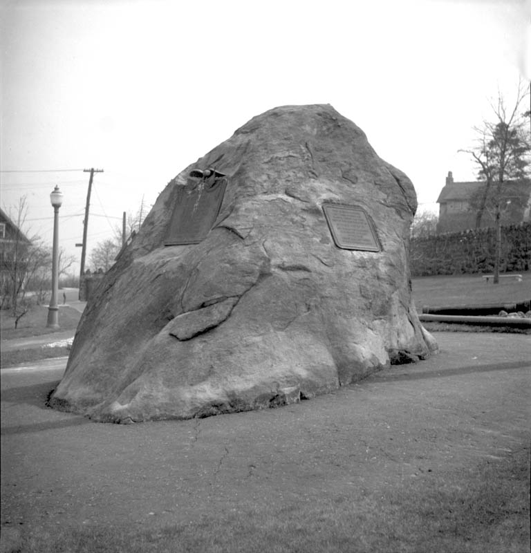
Footloose Forester and his friends growing up on Church Street played in the woods behind their houses and held picnics on huge boulders with names we gave them, such as “The Loaf of Bread”; the “Pillow”, the “Castle” and a few others that are (were) glacial erratics. Those great rocks larger than compact automobiles were on the surface, but only after St. Michael’s Roman Catholic Church bought the land and had part of the woods excavated did it become clear that the sub-surface trove of disconnected boulders justified calling the geologic feature a rock drumlin. Footloose Forester wants the memories of the Loaf of Bread in his memoirs. And for the curious, a historical satellite photo of the woods between Church Street and Route 46 in Netcong can be seen on a Google Earth archived copy at N40º 53′ 42.16″ and W 74º 42′ 34.08″. Since the pre-excavation photo was taken in the winter months, there are no leaves on the trees and you can pick out a few of the larger boulders in the positions they had occupied for the past 25,000 years. The hyperlink photo to the coordinates is: ..\Aerial Photos and Maps\Loaf of Bread Dec 30, 2002.kmz but the pre-excavation photo may require resetting some of the Google Earth parameters.
Living on the Terminal Moraine
Part II
A more detailed written description of the glacial features of the Netcong area has finally gotten into the hands of the Footloose Forester. Several factual details recently relayed to him via the Internet, by a research scientist and professional geologist with the New Jersey Geological Survey, were key in setting the record straight. So, this time, instead of an ongoing chronicles of unverified observations about various things by a rank amateur in the field of geology, the Footloose Forester is delighted to share some concrete information with family and friends who grew up in Netcong. Thanks to the information provided by the professional geologist, however, it can be said that a true drumlin does exist in nearby Andover, New Jersey. It can easily be seen on satellite photographs.
The geologist from the US Geological Survey described the circumstances at Netcong, as follows: … the site of the excavated hillside behind St. Michael’s Roman Catholic Church exposes mixed, unsorted stones, boulders and other glacial till material carried down by the Wisconsin Glacier more than 25,000 years ago. After 700-1000 years, the glacier started to retreat out of New Jersey and was gone about 21,000 years ago….
So either way, the Loaf of Bread, the Castle, the Butter and other glacial giants that we knew as children while playing on top of them, were dumped there about 25,000 years ago, give or take a few thousand years. In the Netcong area, the glacial till has been measured to depths of 50-150 feet deep. The mixed sizes, colors and shapes of the rocks, particularly the huge boulders, come from glacial erosion of granite and gneiss bedrock found in the New Jersey Highlands geologic region north of Netcong; and some smaller boulders composed of quartzite, shale, and some rare limestones from elsewhere. Perhaps geologist Scott Stanford was referring to the dolomite limestone that is quarried from Limecrest outside of Andover. In addition, some of those oddballs were probably plucked from the Kittatinny Ridge complex, even further north than Andover, and transported in and on top of the ice sheet. The Footloose Forester believes that schist is another rock species to be found there, but its identification has not been confirmed.
As it migrated from the Northeast in the vicinity of Sparta, to just a mile or so past Netcong in the direction of Budd Lake, the ice slowed its forward advance. The ragged leading edge of glacier cessation is called the terminus and the evidence of its cessation is witnessed in its gravels, unsorted stones and deposited boulders. Actually, the leading edge of the glacier was 2-3 miles wide, thus the zone along the edges can be called the terminal moraine. So, any way one describes the circumstances, it can be said that Netcong sits on the terminal moraine.
The finer till material is called the matrix and produces the yellowish sandy soil one sees in the deep cut in the banks along the railroad tracks in Netcong. The geologists long ago gave it the name Netcong Till. What has not been eroded or totally buried is still part of an extensive “buried rock ridge system” that is so prominent in Northern New Jersey that one can clearly see its pattern from miles above it, when viewed on satellite photographs. The general compass azimuth alignment of 221 degrees, or NE to SW, shows the exposed portions of the Appalachian Mountains that have not been buried or eroded away. The principal reason for the pattern of seemingly parallel ridges in NE New Jersey is the folding of the bedrock in mountain formation processes, but part of the reason may also be due to the masking effects of glaciers. The broad expanse of the ice sheet broke off parts of the mountain tops and sheared away at their sides; and subsequently buried or masked some irregularities between ridges. Masking and hiding the otherwise irregular shape of the original mountain system produced what the geologists called the Valley and Ridge Province in New Jersey. In any case, the bulk of the ice migrated along the straight line with an azimuth reading of 221 degrees.
The process is sort of like taking a huge spatula to add icing to a cake. Of course, the tops of several of the mountain ridges were higher than the ice sheet was deep, so for the most part, only the valleys filled up with till; and the higher ridges still stick out. The cake underneath got a coating of icing, but although some estimates suggest that the glacier was several thousand feet thick in some places, it did not cover everything, or everywhere. Icing was spread on the cake but there was not enough icing to cover everything. Perhaps the origin of the expression “icing a cake” really started when geologists tried to explain how continental glaciers spread over North America. What we see on satellite photos today is the result of mountain building, followed by shaping of the landscape through erosion and ice scouring. Before the Wisconsin Glacier, however; the Illinoisan Glacier came through Northern New Jersey about 100,000 years earlier and thus also contributed to another episode in shaping the landscape.
Of course, the Chronicles of a Footloose Forester will continue to favor episodes by an observer who wishes to be an anonymous narrator, but nevertheless one who wants to pass along interesting tidbits. He tries not to get too technical, or presumptive; but offers up his observations in the manner of a Hawaiian “talk story” as a way to simplify things for interested parties. Since the latest information comes from the man who actually mapped the glacial features of the Netcong area, it adds to the veracity of what is included. Now, for some updated facts about the glacial geology of the Netcong area, as edited from the geologist’s own descriptions. Of course, the “talk story” interpretations of the Footloose Forester are thrown in, for good measure.
Living on the Terminal Moraine
Part III
After a short one-page article about terminal moraine boulders in Netcong was published in the geology section of About.com in April 2011, it now becomes more apparent that much more of the story should be written. That task is ongoing. Not only is it desirable to provide more evidence, but the accounts of the Wisconsin Glacier, or alternatively named the Wisconsin Ice Sheet, have been published by professional geologists whose accounts substantiate many of the priniciples regarding how and why glaciers affect the shaping of the underlying bedrock and distribute dissimilar rocks and soil materials along their terminal moraines.
The attached section is a partial description of a cut+paste addition about the the Wisconsin Ice Sheet in New York City, as it has been described in a published paper. Fonts have been changed to emphasize that the contents come from another investigator.
The Wisconsin Ice Sheet Continues Its Journey
The nature of glaciers is that as they grind away at rock underneath them, rock gets picked up and travels along with the glacier. After the glacier melts, the rock debris is left behind. In the New York region, the Wisconsin Ice Sheet deposited tons of gravel, pebbles and sand—moving, for example, boulders from the Palisades to Central Park—plowed up topsoil, and leveled the earth, filling in depressed areas with glacial till. Even after the Wisconsin Ice Sheet stopped advancing south and its southern end was melting at the same rate that the ice advanced, it meant that rock debris was deposited and piled up at the southern edge of the ice sheet. This feature is known as a “terminal moraine” and evidence of it (hundreds of feet high in some places) stretches from the southern end of Staten Island across the Narrows and through Brooklyn and Queens. Graniteville Park on Staten Island is situated in a community that makes direct reference to the geologic deposits that were quarried for trap rock from the 1840s to the 1890s.
Acknowledgements and Further Information
A link with the planet's past, geology is alive and well in New York City and especially New York City's parks. Special thanks for this geology lesson goes to Sidney Horenstein, former coordinator of Environmental Programs at the American Museum of Natural History , now the Environmental Educator Emeritus at the institution.
A few ideas about the unearthed boulders at Netcong are matter-of-fact statements that might not garner much attention because not many people know where Netcong is, and even fewer people care. Family and friends who are Facebook subscribers, and people who live in Netcong, can at least recognize the Main Street entrance to St. Michael’s Church parking lot in the photo that accompanied the article. So, this Part III is intended to awaken their interest to a past that is part speculation and part reverie of a child growing up in Netcong.
Today, parishioners who use the parking lot off Main Street, or enter the lot from the Church Street entrance will notice a dozen or more boulders that weigh several tons. A few are 5-6 feet high. What is different about these boulders is that most of them were excavated from below ground, thus are fresh in the sense that they lack signs of weathering and exposure such as the presence of lichens and moss. A few of them were partly buried, so will show both the weathered faces and the unweathered portions that were buried. That is certainly the case with a large pointed boulder that we used to refer to as the Castle. We children growing up on Church Street had to take two or three steps to mount the Castle to then sit in a rough seat-like cradle that we called the throne. The Castle was perhaps the largest of the boulders because when you walked around it, you could see that its base was deep into the ground. On the other hand, the Loaf of Bread was also a monster but it was almost entirely on the surface. It still required mounting from the front or the back; the sides were too tall and too smooth to get a grip. The Loaf of Bread was shaped almost exactly like a loaf of bread and it was everybody’s favorite.
Another remarkable fact about those dozens of huge boulders, and more than a hundred smaller ones, is the disparity of their appearance when you see them standing side by side. A pink granite is standing next to a specimen of gneiss, and another one is reddish sandstone. There are other species that are easy to tell apart. They were all excavated from the same trove of moraine materials that were transported on glacial ice and finally dumped there 25,000 years ago. To tell that story convincingly, however, requires a good deal of speculation. To date there is no detailed description of the process by which a veritable treasure trove of glacial materials was deposited in Netcong, so there is little likelihood that the Footloose Forester will be challenged regarding his views. And his speculative view is this: Some estimates put the thickness of the ice sheet of the Wisconsin Glacier at over 1000 feet; and as it moved slowly southward out of Canada it sheared off rock material from some ridges and even the tops of some hills. Pebbles, stones and even some boulders plucked from rock outcrops were incorporated into the stream of migrating ice. Most transported material was located in parallel bands at the edges of the ice sheet where it came in contact with vulnerable land features. The parallel bands are known as lateral moraines and examples can be seen in photographs of alpine glaciers. The Footloose Forester speculates that as the Wisconsin Glacier neared its terminal point in the vicinity of Netcong, the ice was by then so weakly crusted and so thin that it dropped a large portion of its transported sediments in a few places when topographic irregularities acted as catch basins. If the trove of boulders found between Church Street and Main Street was along and above a lateral moraine, the deposition could include many species of rocks acquired along its path. One final speculation: as the microclimate warmed to the point of melting the glacier as it slowed to a halt, the force of gravity caused an overall settling of the heavier materials into a pocket at the site of the parking lot, while lighter materials were washed out into the outwash plains lower in the terrain. The existence of kames in the region is well established.
Storytelling and speculation aside, any layman can see that the dissimilar rocks ringing the parking lot at St. Michael’s are uncommon. Most show rounded surfaces on more than one side, suggesting polishing in transit rather than being part of the basement complex. Now that they have been excavated and inadvertently used as lane barriers; or pushed aside because of their unmanageable size; or marshaled into decorative mounds of shards, the visitor can experience an outdoor geology lesson with many of the specimens directly underfoot.
